Category Archives: Uncategorized

The Wheels Come Off The Trip

In 10 months, I never missed a flight or a bus, never had any tour or hotel stand me up, and never got sick for more than a day or two.

In the last month, I’ve been mugged (well, they tried), had two busses and one hostel stand me up, missed two flights, and woken up with a fever if 105.8 (giardia).

So it’s a good thing I’d planned to be home for Thanksgiving.

In the words of Charlie Robison,

“So I’m leaving for the last time, honey
I’m never more to roam
I’m gonna pack my bags a little heavy this time
Gonna head my ass back home.”

A Cynic Tries Mountain Climbing

Huayna Potosi, just outside of La Paz, Bolivia stands 20,090 feet (6,088m) tall. If it were in North America, it would be second only to Alaska’s Mt. McKinley. At the summit, the air density is more of less half that of sea level, meaning you’re taking about two breaths for one at sea level. Having said that, altitude alone does not difficulty make. Fitz Roy on the Argentine/Chilean border, for example, is considered one of the hardest climbs on the planet despite standing less than 12,000 feet tall. Huayna Potosi, on the other hand, is considered one of the easier 6,000m summits. You have some options on the route, so may choose to avoid vertical ice climbs altogether. I’d never done anything like this before, so it looked like fun.

IMG_6057

IMG_1567

IMG_1563 (2)

IMG_1687

Well, it isn’t. It’s cold. It’s hard to breathe. It’s uncomfortable. You have to wake up at midnight and hike in the dark and cold and wind. I was so oxygen-deprived at the top that I don’t remember the ascent. I had the worst headache of my life and my nose bled for 10 days afterwards. The air pressure is so low that your body swells, so much so that my watch strangling my wrist looked like a wedding band worn for 40 years. If this were an airplane, the emergency oxygen masks would have dropped from the ceiling 10,000 feet ago.

IMG_1656

IMG_1667

IMG_1685

No one enjoys this, except masochists. Then there are the charlatans, who make up the majority of climbers, who put themselves through this lunacy only to prove–well, to prove what, exactly? That they are more willing to abuse themselves in pursuit of otherwise meaningless goals? That they are capable of going where sane people don’t even have the desire to go? These idiots go around saying things like (I kid you not), “you haven’t lived until you’ve climbed to 6,000m.” Nonsense. In fact you haven’t really known death until you’ve climbed to 6,000m, and you’re a better, healthier, saner person for it.

IMG_1711

Don’t let the smile fool you, that’s just the hypoxia-induced delirium.

IMG_6073

IMG_6077

Whatever it is that makes people do this, congratulations, you can keep it, and good luck to you. As for me, I’m sticking to hiking. My climbing career is over as quickly as it began. And the next time I want to starve my body of oxygen, I’ll just have someone choke me out.

IMG_1717

IMG_1745

IMG_1750

The dog climbs everyday, usually to the summit. I have no idea why.

IMG_5472


South Africa’s Kruger National Park

Safari, Gray Beck-style, consists of renting the cheapest car you can find, driving to Kruger National Park for one night/one morning, and spending the day racing up and down dirt roads at 10 times the posted limit. Anytime you see a car stopped, pull up in a cloud of dust, “poach” the other tourists finds, and move on to the next one. In this way, you can see the “Big Five” (lion, leopard, elephant, rhino, and cape buffalo) in a single morning, plus lots more.

This slideshow requires JavaScript.

This, Ann Beck, is the great, grey-green, greasy Limpopo River.

IMG_1066

And if you’ve never seen the “Battle at Kruger”, one of the most-watched YouTube videos of all-time, there’s no time like the present. Stick with it to the end, I promise everything turns out okay. But it might bring you to tears.

Into The Heart of Africa…By Boat

There isn’t exactly a good route for traveling through the heart of Africa. It’s pleasant enough along the eastern coast, but the infrastructure through the Great Rift Valley is abysmal. In Burundi, I learned of a boat that plies the shores of Lake Tanganyika. The boat, rumor has it, runs twice monthly from Kigoma, Tanzania to Mpulungu, Zambia. But it’s recently been laid up, for months, in dry-dock. In theory, it leaves every other Wednesday, some time in the afternoon. My plan is to head south from Burundi on a Wednesday morning, so this boat might be just the ticket.

The bus departs Bujumbura at 6am, scheduled to arrive Kigoma at about noon. After traversing the worst roads I’ve ever seen for the Burundi section, we enter Tanzania. Within an hour, we’re stopped by the police three times to check our papers, i.e. demand bribes. (I don’t pay them, as a matter of policy. I strictly obey the Foreign Corrupt Practices Act, and if I were to bribe a foreign official, it would be to allow me to do something that isn’t allowed, not something that is.) At 3pm we arrive Kigoma, on the eastern shore of Lake Tanganyika. It was here, on 10 November 1871 that the New York Herald’s Henry Morgan Stanley finally found Dr. David Livingstone, out-of-contact for almost 7 years, and spoke the immortal words, “Dr. Livingstone, I presume?”

Son-of-a-bitch, the boat is here, and in the water! The fastest motorbike ride in history takes me to the port at 350pm. She’s scheduled to sail at 4, so I book a cabin heading south to Zambia, and off we go.

The boat, the “MV Liemba”, it turns out, is rather famous. It was brought overland by the Germans and launched in 1915. With the outbreak of World War I, and finding themselves hard-pressed by a British expeditionary force, the Germans scuttled it in 1916. If you’re read or seen “The African Queen”, you may recognize some similarity–the Liemba was the inspiration for CS Forester’s story. In 1924, after 8 years on the bottom of Lake Tanganyika, the Liemba was re-floated by the British. With occasional repairs, the ship still runs today, 99 years after launch, and having spent 8 years on the bottom of a lake. Unbelievably, everything is original, including the diesel engines.

IMG_4667_edited

IMG_4861_edited

IMG_0901_edited

IMG_4689_edited

Most of the other expat’s were boat enthusiasts, rather than some guy who stumbled on to it. In fact, one group was making their second trip to Tanzania to attempt to catch it. Lake Tanganyika is the second-largest freshwater lake on the planet, and runs 418 miles, north to south, so we’re going to be here for while–three days and nights, if everything goes according to plan. The capacity is said to be 600 people, and the Captain assured me that there were no more than 350 people on board. I personally counted more than that on the forward section alone. I’d bet my paycheck there weren’t less than 1,000 people on board, taking up every single inch of horizontal space. Each time I tried to leave my cabin, the door wouldn’t open because a family would be sleeping immediately outside.

This slideshow requires JavaScript.

But don’t worry about safety, there’s life boat space for a least a couple dozen, and they’re even ready for fires (“fire horse”) and oil spills.

IMG_4665_edited

IMG_4671_edited

IMG_0909_edited


We didn’t leave Kigoma until almost 6pm, by which time we’d accumulated all the baggage of Xerxes’ Myriads–everything from bananas and pineapples to flip-flops to motor oil to bottled water to motorcycles  to glass lamp chimneys to Lady Jelly to something called Sufi–whatever it is, we carried a lot of it.

This slideshow requires JavaScript.

There are no port facilities at the intermediary stops, so the boat is anchored and canoes ferry cargo and passengers to and fro, including at night. It’s a dangerous proposition, especially with the canoes battling for best position, so it was nice to know that when I debarked, I’d be stepping directly on terra firma.

This slideshow requires JavaScript.


Unbeknownst to us “muzungus” (essentially African for “gringo”), one of the passengers was a bride-to-be being delivered to the wedding party. She’s the one with her face covered, in strict observance of local tradition.

Rwanda to Burundi

I’m going to try to avoid going on about the Rwandan genocide–the topic has been covered more thoroughly and more expertly elsewhere. I’ll only say that Rwanda today is probably the cleanest place in Africa and is absolutely stunning, and I can’t recommend it highly enough. That said, I have some lingering suspicions about how well the emotional wounds seem to have heeled. Maybe it’s that life is short in Africa, and so all timelines are compressed. But maybe there’s still something lingering beneath the surface. It isn’t for me to say, or even for me to know. But everyone I meet here over 40, I immediately think, “And exactly what were you doing in 1994?”

Burundi has a similar feel, but the infrastructure is in much worse condition, lacking as it does the enormous and ongoing influx of foreign aid enjoyed by it’s northern neighbor. National borders don’t align with ethnic identity here, and there have been large refugee movements over the decades, so there isn’t exactly a distinct culture between southern Uganda, Rwanda, Burundi, and eastern Congo.

I’m primarily passing through Burundi, but while I’m here, I thought I should have a look for Gustave, the famous killer crocodile. If you’re not familiar with Gustave, he’s a 25 foot long Nile crocodile, notorious for killing over 300 humans along the banks of the Rusizi River. He’s escaped numerous attempts at capture, and bears the scars of numerous bullet wounds. Lest you think this is a joke, well, I can’t vouch for the number of dead, but the crocodile is very much real and very much alive. Unfortunately, (or fortunately, depending on your perspective), Congolese refugees, the Cantonese of Africa, have eaten most of the crocodiles here, though hippos remain abound.

IMG_4624 (2)_edited

IMG_0887_edited

IMG_0879_edited

The concrete structure, formerly covered with fencing, was built in an effort to capture him. According to the locals, he’s moved south down Lake Tanganyika and now resides in Zambia. We weren’t able to confirm this, but there is no sign of him along the Rusizi.

IMG_4626_edited

IMG_4627_edited

A few kilometers away, you’ll find the border with the Congo. Much of the traffic to and from the border is UN peacekeepers, because of the ongoing civil war in eastern Congo. Congo is easily one of the least functional states on the planet, and it seems to be getting worse–war in the east, Ebola in the west, and so it goes.

Perhaps you would think that with all of these problems, including the battles taking place literally within hearing distance, the border would be tightly controlled. You would be wrong. It’s an ordeal to get a visa for Congo, but we simply told the border agents (on both sides) and the Ebola checkpoint personnel that we worked for Oxfam and wanted to cross over for a little while–no passports, no stamps, no nothing, just all handshakes and smiles.

IMG_4628_edited

IMG_4631_edited

When we re-entered Burundi, my driver (unnamed and faceless in the photos, for reasons that will become clear) asked whether I wanted to see the “smugglers crossing”. 6km north of the primary border crossing, down a typical red dirt African road, is a much smaller crossing, manned by a single guard on each side. It’s here that contraband goods cross, as well as guerilla fighters from time to time. The nameless driver, it turns out, moonlights as a beer smuggler (Amstel is brewed under license in Burundi) and so we crossed into Congo for a second time, this time with only a passing wave to the border guards. Earlier in the week, the driver had encountered guerillas here, so we didn’t stray far.

IMG_4633_edited

As for Ebola, well, Congo is a big place, and they’ve had only a handful of cases in the western part of the country. On the drive back, we drove past Burundi’s principle biohazard waste incineration facility, i.e. they truck it out into a field and light it on fire. So that’s reassuring, at least.

IMG_4639_edited

IMG_4634_edited

IMG_4643_edited

Rwandan Safari

At Akagera National Park, Rwanda

A troop of baboons

IMG_4531_editedIMG_4535_editedIMG_4539_editedIMG_4558_edited


Elephant, female

IMG_4542_edited


Bohor reedbuck, male and female

IMG_0601_edited


Female vervet monkey strangling a baby monkey, not her own (don’t worry, baby escaped to mother)

IMG_0602_edited


Topi, males

IMG_0612_editedIMG_4590_edited


Impala, males and females

IMG_0628_editedIMG_0623_editedIMG_0670_editedIMG_4579_edited


Birds, your guess is as good as mine

IMG_0633_editedIMG_0634_editedIMG_0651_edited


Zebra, baby female

IMG_0686_edited


Roan Antelope and Impala, both male

IMG_0690_edited


Cape buffalo, unknown sex

IMG_0712_editedIMG_4587_edited


Giraffe, bachelor males

IMG_0740_editedIMG_4603_editedIMG_4610_editedIMG_0758_edited


Nile Crocodile, dead

IMG_0819_edited


Fish Eagle

IMG_0827_edited


Human, female

IMG_4564_editedIMG_4621_edited


Sunset

IMG_0844_edited

Hiking the Rwenzoris

Between Uganda and Congo (Democratic Republic of Congo, not the Republic of Congo) lie thru Rwenzori Mountains. Behind Kilimanjaro and Mt Kenya, these are the only permanently snow-capped peaks on the continent. But there are many fewer visitors here, which we counted as a positive. It’s also rainy season here, which we did not count as a positive.

IMG_4506_edited

There isn’t much wildlife to see here, apart from the giant earthworms and slugs as big around as my thumb.

IMG_4463_editedIMG_4469_edited


It didn’t rain the entire time, but it felt like it did. It was cold and miserable and otherwise wonderful, traipsing through mud up to our ankles, or sometimes our knees. Evenings were spent playing cards wearing our sleeping bags and clutching hot water bottles.

IMG_4480_edited

The landscape here is unlike anything else I’ve ever found. It rains so frequently, that the mountain is thick with what are essentially alpine swamps. The whole thing is marshland, but steep–how the mountain manages to hold the water, instead of disintegrating into landslides, is beyond me. But it is beautiful. It’s one of those things where we complained the whole time, but knew we’d miss it as soon as we finished. And so it was.

IMG_4495_edited

Before we left, our guide explained to us not to step in “beautiful places.” It took me a day or two to figure out what he meant by that, but I learned–you looked for rocks, or sticks, or plants, or anything else that hadn’t sunk. You could put your face 6 inches from this beautiful alpine meadow and swear it was as firm as a putting green. But the first step onto will sink you in above the knee.

IMG_4519_edited

This is the Mutinda Lookout, at just over 13,100 feet.

IMG_4511

And this is what it looks like when you can actually see. (Imagine me in place of the random guy whose picture I stole on the internet.)

12467725645_b5c52e1fb5_o

This is real trekking here, with tents, boiled water, the whole get-up. Although the water, even boiled, wasn’t the cleanest you’ll find.

IMG_4514_edited

IMG_4520_edited


Cairo

The requisite pyramid pictures.

This slideshow requires JavaScript.

The cave church, with alarmingly graphic carvings.

This slideshow requires JavaScript.

Coptic Cairo, aka garbagetown

This slideshow requires JavaScript.

Other random Cairo pictures

This slideshow requires JavaScript.

McDonald’s Egypt: The Chicken Big Mac

From Egypt, the Chicken Big Mac. I’d expected great things from Egyptian McDonald’s (Lamburger?), but it’s a pretty standard menu. The most unique item is the McArabia, but it’s the same thing as the Greek Mac that I had in Russia, only marketed under a different name.

They did, however, offer the Chicken Big Mac, which is exactly what it appears to be. Take a Big Mac, trade the 1/8 lb beef patties for McChicken patties, and trade the special sauce of mayonnaise. I’d love to tell you more, but it’s basically a bigger, better McChicken. One thing I’ll say for it–the slight crunch of the McChicken patty fits nicely with the softness of the middle bun.  I never understood the middle bun in the Big Mac, but here, it works.

IMG_4191

Istanbul

I’ve long believed Istanbul to be the most beautiful city in the world, because of the combination of an incredible natural setting, amazing architecture, and a history that goes back millennia. That said, I’ll let it speak for itself.

Mosques of Sulthanamet

This slideshow requires JavaScript.

The Golden Horn and the Bosporus (There is a destroyed Genoese castle where the Bosporus opens to the Black Sea. It’s my favorite place in the world, but is also a Turkish military outpost, so is now off-limits to the public.)

This slideshow requires JavaScript.

Istanbul by Night

This slideshow requires JavaScript.

Leaving Karabakh

I mentioned earlier that there are two roads between Armenia and Karabakh, the northern route and southern route, and that you may only enter by the southern route. I chose to leave by the northern route, and now understand why you can only enter by the southern route. It took 8 hours to do 130 miles of unpaved road that tested the Niva, and it’s driver, to their limits. By far the most terrifying part of visiting Karabakh was the drive out. In fact it was the most terrifying part of my journey–way worse than run-ins with the police in the Philippines, being attacked by dogs in Georgia, flying over the fighting in Donetsk (which didn’t end well for the Malaysian Airlines flight that tried it), or hearing (and feeling) nearby shelling on the frontlines in Karabakh, in addition to myriad other traumas that I’m sure I’m forgetting at the moment.

The road passes through the most beautiful terrain, and bombed-out villages, and through canyons barely wide enough to accommodate the road.

20140918_190705_edited

20140918_205524_edited

20140918_205516_edited


But the real fun begins with the hill-climb, in the fog. The entire mountain is slippery gray clay, that’s so steep and so slippery that you can’t stand still on it, a lesson I learned the hard way. There are no guardrails. The fog was so thick that you couldn’t see 100 feet in front of you. Once I had forward momentum going uphill, I didn’t dare slow down, but I never knew when the next hairpin would come. Going downhill, the slightest touch would lock up the brakes and the car would actually pick up speed as the car slid downhill–the only move was to slow the car by spinning the tires in reverse and at least getting the arresting force of the mud slung forward–Newton’s 3rd law at work. A number of times, I’d slow the car going uphill only to find that as I lost momentum, the car would come to a complete stop… and start sliding backwards. The only choice was to put in reverse and drive my way out, or try to slow it by spinning the tires in forward. So why didn’t a find a flat spot and just stop? In a word, nightfall.

20140918_211658_edited

20140918_212513_edited

20140918_212506_edited

20140918_211706_edited

I was actually happy to finally reach this most-potholed-road, because of, you know, traction.

20140918_213756_edited

When I finally cleared the mountains, the most beautiful vistas appeared and made it all worthwhile. It did not, however, immediately stop the trembling.

20140918_215611_edited

20140918_222626_edited

20140918_220744_edited

20140918_222537_edited

The rental car agency had a surcharge for returning a visibly dirty car. I gladly paid it.

20140918_212532_edited

“…But You Cannot Go to Agdam.”

Without exception, when was told “You must go to Karabakh…” it was followed by “…but you cannot go to Agdam.”

I first heard this from backpackers, then Armenians, and finally from the Karabakh Foreign Ministry. Naturally, being told that I couldn’t go only encouraged me. What was this Agdam? What had happened there? And why was everyone that I met telling me that I couldn’t go. I resolved to find out.

Agdam in in Azerbaijan proper. That is to say that it is not in the area of Karabakh, which claims independence. It is instead in a buffer zone that the military maintains around the region. Even Karabakh recognizes Agdam as part of Azerbaijan, and yet they occupy it for military purposes. Agdam was formerly a city of over 100,000, primarily Azerbaijani. It was completely destroyed during the war, and, save for some looting, has remained that way ever since.

I find being told where I can and can’t go distasteful, and so have some experience going places that I’m not allowed to go. There are lots of strategies, but all successful ones amount to playing dumb. You can go by yourself and act lost, or you can go with a local and act ignorant. The area is largely carpeted with anti-personnel mines, so going alone didn’t appeal to me. You have to strike a perfect balance between not appearing to be an idiot and not appearing to be an intelligence agent. My advice–go when it’s raining (because even soldiers, or maybe especially soldiers, don’t like rain), wear neutral colors (but not like a soldier or cat burglar), say as little as possible, and look for someone who NEEDS the money (drivers of barely-alive cabs that are low on gas are perfect.) Have them take you somewhere legitimate first, and feel them out. Then ask them to take you to the place that you cannot go. But you may observe that none of that keeps them from thinking you’re a foreign agent. That part is easy–drink a juicebox, or, failing that, a can of soda through a straw–no foreign agent in history has sipped from a straw. My guy (who’ll remain unnamed) agreed, and at a fair price, but he was wily–he demanded that I not take a camera or phone in the car. It’s one thing to be there, and quite another thing to take photos–this is the frontline of a war, after all. It’s not arrest that you fear, because arrest is very much a civilian concept. Detention is probably a better term, but it’s even more complicated here, because this is an unrecognized state, and so there is no consular support here.

The focal point of Agdam is a 150 year old Persian mosque, now used as a stable. A local rite of passage for Karabakh youths for the last 20 years or so has been to desecrate the mosque by climbing to the top of one of the minarets and drinking a beer as fast as he can, in full view of the Azeri frontline. Azeri snipers particularly dislike the desecration of their mosque, and so have both minarets perfectly sited–hence the rite of passage. Because the driver insisted that I leave all cameras behind, I don’t have any pictures of downtown Agdam–not that there’s much to see. But I look sort of Armenian, and my Lada Niva looks very Armenian, so I went back on my own–not into the center, because the rain had subsided and the patrols were out. I went as far as I could, before I was going to have stop for a roadblock and explain myself*, but the troops seemed comfortable enough with me turning around and heading back the way I came.

The outskirts of Agdam.

20140918_175009_edited


A cleared minefield, thanks to the UK-based NGO, “The Halo Trust”, who do fantastic work all over the world.

20140918_175352_edited

Agdam in the distance.

20140918_175741_edited

An Armenian/Karabakhi bunker from behind, facing Azerbaijan.

20140918_175906_edited

An Armenian/Karabakhi bunker from the front, facing Armenia.

20140918_180712_edited

An uncleared minefield between the lines, with the hulks of tanks and APCs from the war.

20140918_180025 (2)_edited

20140918_180550_edited

An Armenian village, totally destroyed by the fighting. It’s on a smaller scale, but gives a flavor of Agdam.

20140918_182923_edited

20140918_183047_edited

20140918_185628_edited


A blown up bridge.

20140918_183347_edited


*If I’d had to explain myself, it was all planned. As I said, the game is to act ignorant, confused, and oblivious. The conversation would have gone something like this:

Soldier: What are you doing here?
Gray: Captain, I’m sure glad to see you. I’m looking for a place called Agdam, and I’ve gotten myself half lost. I’m visiting from America, why do you ask? (always address him by one rank, but only one rank, above his actual rank)
Soldier: You cannot be here. This is a restricted area.
Gray: You don’t say? But I think I have the proper visa here in my passport, see?
Soldier: This allows you into Karabakh, not Agdam.
Gray: Ah, I see. But I have my papers here, from the Foreign Ministry, and they plainly say that I can travel to Agdam.
Soldier: Your papers do not say that you can go to Agdam.
Gray: Of course they do, look here. (points at “Askeran”)
Soldier: That says “Askeran”, not “Agdam”.
Gray: Ah, I see that now. That Consular Officer really has the worst handwriting. I had no idea, but it’s a good thing you stopped me before I got to Agdam.
Soldier: We’re in Agdam now.
Gray: That can’t be right, my GPS shows that we’re in Askeran, see?
Soldier: No, if you zoom in, you’ll see that you’re in Agdam.
Gray: I see that now. Well, good thing you found me, I could have gotten myself into trouble! You know, this place is a real mess, and looks dangerous, what with the soldiers and landmines and all. You all really shouldn’t be encouraging tourists to come here. (walks away)

(If things get particularly dicey, you go straight to “Is there any way that we can resolve the issue right now?”. If they’re dense, you follow it with “I’d by happy to pay any additional charges or fees.” Finally, if things get really bad, you can use the “ejection seat”. But it should be treated like an ejection seat, it’s expensive and dangerous, but it works when nothing else will. Produce a $100 bill–it needs to be USD, not Euros or the equivalent in local currency. Fold it twice, slip it into the front shirt pocket of the person you’re dealing with, without saying a word, and walk away.)

“You Must Go To Karabakh…”

“You must go to Karabakh…”

So said literally every person I’d spoken to about Armenia. For Armenians, it is considered the most beautiful part of the region. For backpackers, it’s a wild and remote region, largely inaccessible, often dangerous, and therefore likely to improve their feelings of self-worth based on “authenticity” and “adventurousness”. Either way, everyone suggested that I go. For some reason, the statue that is pictured in the banner of the post is considered the symbol of Karabakh.


20140918_172351_edited

 Nagorno-Karabakh was once an autonomous republic within Azerbaijan. The people there were majority Armenian, and voted to secede Azerbaijan and join Armenia. A war resulted, with Armenia fighting on behalf of Karabakh. It ended with Armenia/Karabakh occupying Nagorno-Karabakh, as well as some adjacent parts of Azerbaijan proper. Both sides behaved dreadfully, and Karabakh is now bereft of Azerbaijanis. Ethnic violence including targeting of civilians and destruction of towns and cities happened on both sides. It’s now de facto independent but also largely a client state of Armenia.

IMG_0571_edited

“Nagorno” simply means “mountainous”, so everyone refers to it as simply “Karabakh”. The Armenians consider this an Azeri term, and so properly call it “Artsakh”, but even they slip up and call it “Karabakh”. The region is entirely forbidding terrain, and is considered the most beautiful part of Armenia, or Azerbaijan, or whatever. If you look at breakaway regions, you’ll learn very quickly that people only fight over beautiful places. (Or, in a few rare instances, resource-rich areas.) No one, for example, is fighting over western Kansas anytime soon.

IMG_0550_edited

Once again, the trip was overland and off-road, so once again, I arranged the local crag-hopper, the Lada Niva. Getting in is a relatively straightforward and beautiful drive from Yerevan. There are two roads between Armenia and Karabakh, but foreigners can only enter via the southern road. In recent years, it’s been mostly paved, primarily thanks to the Armenian-American community, primarily Kirk Kerkorian.

IMG_0556_edited

Once you cross the border, you have only three hours to reach the Karabakh Ministry of Foreign Affairs (a skeleton operation, as they aren’t recognized as a country, and so don’t have “foreign affairs” per se). There you apply for and receive a visa, which grants you access, and insures that you can never again visit Azerbaijan. You also receive your “papers”, that specify exactly where you can go. If you aren’t specifically granted access, you cannot go. Think Vichy France.

20140930_023654 20140930_024003

The main town, Stepanakert, is nestled in a small saddle valley, and looks and feels much like any other town. But nearby, things are much different. It’s only a few miles to the front-lines, and fighting has increased in recent months. Also nearby is Shushi, formerly a majority-Azeri town (inside Karabakh, a majority Armenian-region, which was inside Azerbaijan, a majority-Azerbaijani country), now occupied by Armenians who fled Azerbaijan. There are similar towns in Azerbaijan, where Azerbaijani refugees moved into the homes of Armenians who’d fled.

IMG_0599_edited

IMG_0594_edited

There is an airport that was constructed with Armenian financing in 2011. It is brand-new, and state-of-the-art. But no plane has ever landed or taken off. Because no state (including, strangely, Armenia) recognizes Karabakh as an independent state, the International Civil Aviation Authority considers it Azerbaijani airspace. And so it seems that no traffic is likely for the foreseeable future. (Realistically, it’s almost certainly intended not as a civilian airport but as a military airstrip in the event of hostilities, disguised as a civilian airport. Surely they knew beforehand that no one would be able to fly in or out.)

20140918_171509_edited

There are a number of monuments around to the Karabakhi/Armenian forces, mostly tanks from the conflict, now outdated, with their turrets always aimed toward Azerbaijan. (Don’t worry, the explosive reactive armor on this T-72 was removed, and only the boxes remain.)

20140918_173804_edited

20140918_173555_edited

20140918_173536_edited

Nearby is Agdam, a strange and almost mythical place, closed to the outside world. Tomorrow, that’s where we’ll try to go.

Armenia

The Caucasus is home to some of the oldest religious traditions in the world. The Georgian Jews, for example, are neither Ashkenazi nor Sephardic, instead tracing their history to the Babylonian Exile when Nebuchadnezzar destroyed the First Temple in the 6th Century BC.

But Armenia is particularly known for deep religious tradition, largely as the oldest Christian country in the world, adopted in AD 301. Even today, the Armenian religious tradition is deeply archaic, having split from what is now known as Eastern Orthodoxy in 451. Monasteries abound, tracing their lineage back well over a thousand years. The monastery pictured below once contained the spear that pierced Christ’s side–one of multiple claimants, to be sure, but the senior claimant if nothing else.

This slideshow requires JavaScript.


Nearby is a Greek temple dating to the 1st century AD, and the only such “pagan” temple in this part of the world to have survived.

This slideshow requires JavaScript.

The economic development of Armenia has been restrained since the war with Azerbaijan. To Armenia’s west lies Azerbaijan. To the east lie Turkey and an Azerbaijani exclave. Those borders have remained strictly closed since the early 1990s. That leaves land borders to Iran in the south and Georgia in the north, which have had myriad troubles of their own in that time. Being in Armenia may be as close to being in the USSR as still possible. (With the exception of Belarus, which I’ve not seen.)

Just across the Turkish border is Mount Ararat, pictured below, famous as the resting place of Noah’s ark, according to the Book of Genesis.

This slideshow requires JavaScript.

Just south of Ararat is Iran. The houses in the photo are in Armenia. The  mountains in the distance are in Iran, and this is as close as I want to get for the foreseeable future. (Bizarrely, the small dark hill behind the tree behind the houses, but well in front of the mountains, is in Turkey. I might be <10 miles from Iran, but at least there’s a NATO member between me and them.)

IMG_0500_edited

Armenia is also home to one of the largest Yazidi communities in the world outside of Iraq. The Yazidi are one of those ancient ethno-religious communities that no one had ever heard of until last month, when ISIS began executing them in Iraq. The Yazidi are often called fire-worshippers, descending from ancient Zoroastrianism (Zarathustrianism). They are ethnic Kurds, and so are disliked in the Arab and Turkish worlds. They also have a term for a deity called “Shay-tan”, often perverted into “Satan” in the Muslim world, and so are accused of worshipping Satan (the devil, not Sam’s brother). Being Kurds and apostates, they start life with an 0-2 count in the Islamic world. As a result, they’re pretty secretive, particularly when it comes to religious practices. Pictures of their village and temple (I don’t know the proper term) are below. The village looks like any other Armenian village, and the temple, as far as I can tell, is used for playing pool.

This slideshow requires JavaScript.

Azerbaijan: The Original Petro-State

Long before Dubai, Brunei, Qatar, or Saudi Arabia, Azerbaijan was the original petro-state.  It’s now controlled by the autocrat Ilham Aliyev, son of the previous autocrat and former head of the Azerbaijan KGB and the Azerbaijan SSR, Heydar Aliyev. The Aliyev’s have long been the west’s favorite dictators because they’re happy to sell oil and gas to the west, and better yet, to give western companies concessions to do it. People I speak seem ok with autocracy, because it’s stable and successful and peaceful, and the only thing you’re forbidden from doing is criticizing the President. As for me, I wouldn’t trade freedom-of-conscience for all the material goods in the world, so I can’t say that I relate. And it may be all of those positive things now, but like all petro-states, when the bottom falls out of petroleum prices (as it tends to do), God help them.
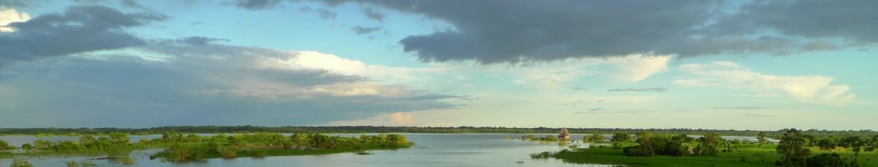
The peninsula on which Baku sits is a veritable wasteland. Not only is the oil and gas here plentiful, it’s close to the surface and cheap to extract. This is the original petro-state. Long before Arab oil was even an idea, Azerbaijan was a global powerhouse. In 1901, more than half of the world’s oil was coming from Azerbaijan. There are pumpjacks (the oil wells that move up and down and look like grasshoppers) covering the horizon. Left to itself, oil here pools on the ground. It was here that up from the ground come a bubblin’ crude. The environmental wasteland isn’t even a human-imposed condition like elsewhere in the USSR, like the Aral Sea. No, here it isn’t a matter of man polluting Mother Nature, but of Mother Nature polluting herself.

IMG_3538 (2)_edited

Ok, so it’s also a matter of man polluting Mother Nature.

IMG_3409_edited
Everything here revolves around petroleum and fire. The whole country smells like a gas station. Sulfur fumes periodically waft over the city. Sculptures in parks resemble flames.

IMG_3537_edited
The locals are quick to boast of the world’s only flame-shaped tower, as though it’s a triumph of engineering rather than merely a triumph of poor taste.

IMG_3627_edited
There’s a Zoroastrian temple for fire-worship. It was originally fed by naturally occurring vent, but nearby drilling ended that, so now fed artificially.

IMG_3507_edited

However, just outside the city there is a place where natural gas vents naturally.  Interesting picture of orange rocks, you say?

IMG_3554_edited

They’re actually on fire. Ragingly on fire.

IMG_3581_edited

IMG_3572_edited

I’d love to tell you a story about ancient religions practicing here for ten thousand years, or some such thing (and I will, if you really want), but the truth is that they think this fire was accidentally started by a shepherd in the mid-1970s when he stumbled across the gas vent.

The first impression of Azerbaijan is very European. But once you go inside, it’s the tackiest place in the world. It’s also the whoringest place in the world. It’s famous for nightlife, but really they just mean there are lots of clubs and lots of hookers. The idea of sleeping with someone who, you know, actually wanted to, seems completely foreign to people here. And even though it’s Muslim, the beer flows here like Oktoberfest. The people here are incredibly friendly to me, as they’ve been almost everywhere I go. But, like everyone, there’s a darker side.

Everyone in the Caucasus has problems with someone else. Here, the enemy is Armenia. Turkey (on Armenia’s other border) and Azerbaijan both have closed borders with Azerbaijan. So to visit all three, I’ll have to travel from Georgia to Azerbaijan, then back to Georgia, then to Armenia, then back to Georgia, then to Turkey. And I’ll have to do in that order, because you can’t go to Azerbaijan if you’ve ever been to Nagorno-Karabakh, which is both the result and the source of the animosity. Tensions between the Christian Armenians and Muslim Azerbaijanis and Turks go back centuries. At the break-up of the Soviet Union, Nagorno-Karabakh was a majority-Armenian region within Azerbaijan. Nagorno-Karabakh tried to secede from Azerbaijan and join Armenia, and ethnic violence broke out. Azerbaijanis were driven from Armenia, and Armenians were driven from Azerbaijan. You can read all about it on Wikipedia, but long story short, Armenia/Karabakh won the contest, humiliating Azerbaijan. Today, Nagorno-Karabakh is in a state of frozen conflict. It’s de facto independent, though closely tied to Armenia, but unrecognized by any UN member state, including Armenia.

Zvi Rex once said, “The Germans will never forgive the Jews for Auschwitz.” To be sure, it isn’t an exact parallel, but Azerbaijan and Turkey will never forgive the Armenians for the genocide of the 1915. Further exacerbating the social psychological complex is the Azerbaijani humiliation in the early 1990s. Azerbaijan has 3 times the population of Armenia and 5 times the GDP. Yet Armenia presently controls over 10% of Azerbaijani territory. Aliyev has announced his determination to have it back, by force if necessary. To that end, Azerbaijan now has a military budget the size of Armenia’s total budget. Russia supplies both, and keeps a military base in Armenia, so the situation remains tentatively stable. But Aliyev seems determined to restore Azerbaijani pride. If Azerbaijan trips the Russian tripwire, it risks bringing Russia in. Which probably means Turkey, a full NATO member, joins as well, on the other side. Add in Iran (along the southern border of both countries), and the jihadi connections with the Azeribaijani side from the early 1990s, and a little bit of trouble here could have far-reaching global consequences. It may not be as sexy in foreign affairs circles as pan-Arab nationalism, Chinese domination of the South China Sea, or Russia choking off European gas supplies—but it’s very much a powder keg, and in a place where loyalties and alliances are less a matter of expediency and more a matter of fundamental self-identity.

And it’s getting worse. Russia and the west have spent the decade distracted elsewhere. Both countries were engaged in NATO’s Partnership for Peace program. In 2004, soldiers from many NATO PfP nations met in Budapest for language training, including two Azeribaijanis and two Armenians. One of the Azerbaijanis, Ramil Safarov, bought an axe one evening and spent the night sharpening it. The next morning, he entered the room if one of the Armenian soldiers and hacked him to death. He was arrested and convicted to life in Hungarian prison. During his interrogation, he said, “I regret that I hadn’t killed any Armenian before this…the reason why I committed the murder was that they passed by and smiled in our face.” In 2012, Safarov was extradited to Azerbaijan to serve the rest of his sentence. Upon arrival, he instead received a hero’s welcome. He was retroactively promoted, given an apartment and back-pay, and praised throughout the country. Such is depth of ethnic tension here.

In July and August of this year, shelling broke out along the border, resulted in 15 deaths. You can’t get to Nagorno-Karabakh from here, so I’ll have to head back through Georgia, but in a couple of days, we’ll look at the conflict from the other side.

This slideshow requires JavaScript.

Chiatura Cable Cars

There’s a mining town in Georgia called Chiatura. It was made famous in the revolutionary period as the main Bolshevik stronghold in otherwise Menshevik Georgia, mainly because the horrid living and working conditions further radicalized the local workers.

In 1954, a system of cable cars (or gondolas, or tramways, depending on what part of the English-speaking world you call home) was installed to ferry workers between the town and the mines. Most are still in operation, and none have been updated. They look terrifying, but I’m not sure that they’re really all that dangerous. An American mining consortium now owns the mines but by agreement with the government continues to operate the cable cars for free. The town has become somewhat notable in recent years after a number of articles were written about the area, all with sensationalist titles and content. (All mention Stalin, but they have nothing whatsoever to do with him–he died in 1953, before they were built.) But as they’ve already written the story, there’s no real need for me to repeat it in detail.

Stalin’s Rope Roads” (The Atlantic Monthly)
Stalin’s cable car: Death-defying ‘metal coffins’…” (The Daily Mail)
Stalin-Era Cable Cars Make for Thrilling Daily Commute…” (The Wall Street Journal)

This slideshow requires JavaScript.

Svanetia

When I was last in Georgia, I saw much of the country, but everyone lamented that I’d not seen Svanetia. They described it as the most beautiful place in Georgia, and maybe the most beautiful place on the planet. They were right.

IMG_2936_edited
The area is populated by the insular and mysterious Svanetians. Everyone here are “mountain people”, but the Svanetians are “mountain people” even to other “mountain people.” The Svanetians were one if the few peoples not conquered by the Mongolian horde. To this day, they’ve only been placated rather than conquered.

Svanetia is not easy to get to. There was formerly a helicopter providing daily service from Tbilisi, but no more. Now a Twin Otter flies from Tbilisi thrice weekly, but sells out weeks in advance. Or you can drive. But the conditions on the main east-west road in Georgia aren’t great, and after that, you’re rock-hopping for hundreds of kilometers. Fortunately, I found someone willing to rent me the right tool for the job—the Lada Niva (since renamed the Lada 4×4). Lada was the mainstream Soviet brand of car, but the company has continued to operate, more or less, to this day.

IMG_2813_edited
I put this thing through its paces, working it harder than a Road & Track road test, and so feel well-positioned to tell you something about it. The Niva is sprung like a dumptruck. It has a torque curve like the Matterhorn. Its single-overhead cam 1.7L inline-4 connected to a 5-spead manual gearbox pushes it up to a top speed of 91mph. I can vouchsafe that in the right conditions, you can hit 91mph—I have. But that’s its terminal velocity. With the aerodynamics of a box of Kleenex, this car wouldn’t go any faster if you dropped it out of an airplane. It weighs about 2,500 pounds, gets 26 mpg highway, generates a whopping 85 peak horsepower at redline, and does 0 to 60 in 19 seconds flat. For comparison, you could race a 2015 Lada Niva against a 2015 Ford F150 2.7L Ecoboost carrying another Lada Niva in the bed. The F150 would beat the Niva to 60mph by 10 seconds while getting better gas mileage. Cutting edge design, the Niva is not.

IMG_2816_edited
On the other hand, it has a classic look, and the poor stereo quality is irrelevant in a land with no radio stations. And it’s only 5.9 feet wide (it’s as tall as it is wide), so you can get in and out of some very tight spaces. There are a couple of routes that you can take, but the Niva is not built for the highway, so I chose the off-road route. Over 5 hours of unpaved road, it didn’t as much as break a sweat, including driving perpendicularly over railroad tracks at not-a-railroad-crossing. Thus we get to what must be the single best driving road in the world. There may be short stretches of other roads that are, but this is the best covering any meaningful distance—it beats the Pacific Coast Highway a couple of times over. You pass alongside the most beautiful turquoise reservoir, up and down hairpins, and through dozens of tunnels blasted from the granite with concrete or other finishing. Falling rocks signs are common here, and they mean it—rock patrols drive the road regular to clear the rockfalls, but you still need to avoid a dozen or so fresh falls each time you drive—there must be hundreds a day.

IMG_3204_edited

IMG_3186_edited

IMG_3175_edited

I have no idea what makes the water so turquoise. Stranger still, the turquoise water is separated by gray water by a logjam.

IMG_3180_edited
You also never know when you’ll encounter an eighteen-wheeler or a cow or a stretch where landslides have reduced the road to less than one lane. If you push the Niva as hard as it can be pushed, you can almost, but only almost, kill yourself. Your foot is always on the floor, moving down through the gears as quickly as you can, windows down, Dire Straits playing on your phone because the radio doesn’t work, cool alpine breeze through the windows. You might be chugging along at 45mph, but you feel like you’re running a tenth of a second off the split in the Pikes’ Peak Hill Climb.
The drive was worth the trip on its own, but even if that isn’t your bag, Svanetia is worth it even if you have to walk. Here’s the view from my bedroom window.

IMG_3092_edited

There are plenty of hikes to do ranging in difficulty from walk-in-the-park to you-better-have-brought-oxygen. I only had one day of hiking, but wanted a full day of hiking. I had the option of hiking up to a glacier or up to a mountain peak. They insist on guides for hikes, but not wanting to pay for it, I decided to do the mountain peak hike alone. I followed what I thought was the right route, and ended up at the glacier. So it all worked out, in a way.

IMG_2949_edited
There wasn’t much excitement, other than the views, though it’s exhilarating to spend some time in such beautiful country entirely alone. I did encounter one local Svanetian shepherd when one of his dogs attacked me from behind—he got a tooth stuck in my gaiters, so didn’t draw blood (h/t Mountain Laurel Designs). But don’t pity me—you ought to see the dog. The shepherd was friendly enough but spent 10 minutes trying to speak to me in Svan. Svan is an offshoot of Georgian, but it shot off, as it were, a few thousand years ago, so the two are now mutually unintelligible. Georgian itself it was linguists call an “isolate”, with a unique and very strange script and more consonants than you can imagine. It’s unrelated to any other language group in the world. Long story short, there are maybe 20,000 people in the world who speak Svan, and clearly the American in technical gear is not one of them, but that concept was lost on this man—perhaps he thought the whole world speaks Svan.

This slideshow requires JavaScript.