Images

A Cynic Tries Mountain Climbing

Huayna Potosi, just outside of La Paz, Bolivia stands 20,090 feet (6,088m) tall. If it were in North America, it would be second only to Alaska’s Mt. McKinley. At the summit, the air density is more of less half that of sea level, meaning you’re taking about two breaths for one at sea level. Having said that, altitude alone does not difficulty make. Fitz Roy on the Argentine/Chilean border, for example, is considered one of the hardest climbs on the planet despite standing less than 12,000 feet tall. Huayna Potosi, on the other hand, is considered one of the easier 6,000m summits. You have some options on the route, so may choose to avoid vertical ice climbs altogether. I’d never done anything like this before, so it looked like fun.

IMG_6057

IMG_1567

IMG_1563 (2)

IMG_1687

Well, it isn’t. It’s cold. It’s hard to breathe. It’s uncomfortable. You have to wake up at midnight and hike in the dark and cold and wind. I was so oxygen-deprived at the top that I don’t remember the ascent. I had the worst headache of my life and my nose bled for 10 days afterwards. The air pressure is so low that your body swells, so much so that my watch strangling my wrist looked like a wedding band worn for 40 years. If this were an airplane, the emergency oxygen masks would have dropped from the ceiling 10,000 feet ago.

IMG_1656

IMG_1667

IMG_1685

No one enjoys this, except masochists. Then there are the charlatans, who make up the majority of climbers, who put themselves through this lunacy only to prove–well, to prove what, exactly? That they are more willing to abuse themselves in pursuit of otherwise meaningless goals? That they are capable of going where sane people don’t even have the desire to go? These idiots go around saying things like (I kid you not), “you haven’t lived until you’ve climbed to 6,000m.” Nonsense. In fact you haven’t really known death until you’ve climbed to 6,000m, and you’re a better, healthier, saner person for it.

IMG_1711

Don’t let the smile fool you, that’s just the hypoxia-induced delirium.

IMG_6073

IMG_6077

Whatever it is that makes people do this, congratulations, you can keep it, and good luck to you. As for me, I’m sticking to hiking. My climbing career is over as quickly as it began. And the next time I want to starve my body of oxygen, I’ll just have someone choke me out.

IMG_1717

IMG_1745

IMG_1750

The dog climbs everyday, usually to the summit. I have no idea why.

IMG_5472


Rwanda to Burundi

I’m going to try to avoid going on about the Rwandan genocide–the topic has been covered more thoroughly and more expertly elsewhere. I’ll only say that Rwanda today is probably the cleanest place in Africa and is absolutely stunning, and I can’t recommend it highly enough. That said, I have some lingering suspicions about how well the emotional wounds seem to have heeled. Maybe it’s that life is short in Africa, and so all timelines are compressed. But maybe there’s still something lingering beneath the surface. It isn’t for me to say, or even for me to know. But everyone I meet here over 40, I immediately think, “And exactly what were you doing in 1994?”

Burundi has a similar feel, but the infrastructure is in much worse condition, lacking as it does the enormous and ongoing influx of foreign aid enjoyed by it’s northern neighbor. National borders don’t align with ethnic identity here, and there have been large refugee movements over the decades, so there isn’t exactly a distinct culture between southern Uganda, Rwanda, Burundi, and eastern Congo.

I’m primarily passing through Burundi, but while I’m here, I thought I should have a look for Gustave, the famous killer crocodile. If you’re not familiar with Gustave, he’s a 25 foot long Nile crocodile, notorious for killing over 300 humans along the banks of the Rusizi River. He’s escaped numerous attempts at capture, and bears the scars of numerous bullet wounds. Lest you think this is a joke, well, I can’t vouch for the number of dead, but the crocodile is very much real and very much alive. Unfortunately, (or fortunately, depending on your perspective), Congolese refugees, the Cantonese of Africa, have eaten most of the crocodiles here, though hippos remain abound.

IMG_4624 (2)_edited

IMG_0887_edited

IMG_0879_edited

The concrete structure, formerly covered with fencing, was built in an effort to capture him. According to the locals, he’s moved south down Lake Tanganyika and now resides in Zambia. We weren’t able to confirm this, but there is no sign of him along the Rusizi.

IMG_4626_edited

IMG_4627_edited

A few kilometers away, you’ll find the border with the Congo. Much of the traffic to and from the border is UN peacekeepers, because of the ongoing civil war in eastern Congo. Congo is easily one of the least functional states on the planet, and it seems to be getting worse–war in the east, Ebola in the west, and so it goes.

Perhaps you would think that with all of these problems, including the battles taking place literally within hearing distance, the border would be tightly controlled. You would be wrong. It’s an ordeal to get a visa for Congo, but we simply told the border agents (on both sides) and the Ebola checkpoint personnel that we worked for Oxfam and wanted to cross over for a little while–no passports, no stamps, no nothing, just all handshakes and smiles.

IMG_4628_edited

IMG_4631_edited

When we re-entered Burundi, my driver (unnamed and faceless in the photos, for reasons that will become clear) asked whether I wanted to see the “smugglers crossing”. 6km north of the primary border crossing, down a typical red dirt African road, is a much smaller crossing, manned by a single guard on each side. It’s here that contraband goods cross, as well as guerilla fighters from time to time. The nameless driver, it turns out, moonlights as a beer smuggler (Amstel is brewed under license in Burundi) and so we crossed into Congo for a second time, this time with only a passing wave to the border guards. Earlier in the week, the driver had encountered guerillas here, so we didn’t stray far.

IMG_4633_edited

As for Ebola, well, Congo is a big place, and they’ve had only a handful of cases in the western part of the country. On the drive back, we drove past Burundi’s principle biohazard waste incineration facility, i.e. they truck it out into a field and light it on fire. So that’s reassuring, at least.

IMG_4639_edited

IMG_4634_edited

IMG_4643_edited

Hiking the Rwenzoris

Between Uganda and Congo (Democratic Republic of Congo, not the Republic of Congo) lie thru Rwenzori Mountains. Behind Kilimanjaro and Mt Kenya, these are the only permanently snow-capped peaks on the continent. But there are many fewer visitors here, which we counted as a positive. It’s also rainy season here, which we did not count as a positive.

IMG_4506_edited

There isn’t much wildlife to see here, apart from the giant earthworms and slugs as big around as my thumb.

IMG_4463_editedIMG_4469_edited


It didn’t rain the entire time, but it felt like it did. It was cold and miserable and otherwise wonderful, traipsing through mud up to our ankles, or sometimes our knees. Evenings were spent playing cards wearing our sleeping bags and clutching hot water bottles.

IMG_4480_edited

The landscape here is unlike anything else I’ve ever found. It rains so frequently, that the mountain is thick with what are essentially alpine swamps. The whole thing is marshland, but steep–how the mountain manages to hold the water, instead of disintegrating into landslides, is beyond me. But it is beautiful. It’s one of those things where we complained the whole time, but knew we’d miss it as soon as we finished. And so it was.

IMG_4495_edited

Before we left, our guide explained to us not to step in “beautiful places.” It took me a day or two to figure out what he meant by that, but I learned–you looked for rocks, or sticks, or plants, or anything else that hadn’t sunk. You could put your face 6 inches from this beautiful alpine meadow and swear it was as firm as a putting green. But the first step onto will sink you in above the knee.

IMG_4519_edited

This is the Mutinda Lookout, at just over 13,100 feet.

IMG_4511

And this is what it looks like when you can actually see. (Imagine me in place of the random guy whose picture I stole on the internet.)

12467725645_b5c52e1fb5_o

This is real trekking here, with tents, boiled water, the whole get-up. Although the water, even boiled, wasn’t the cleanest you’ll find.

IMG_4514_edited

IMG_4520_edited


McDonald’s Qatar: The McRoyale

The McRoyale, in Qatar (and other Middle Eastern countries) is a 1/3 lb beef patty, sesame bun, ketchup and mayonnaise, lettuce, tomato, pickle, and onion. It’s the closest thing McDonald’s offers to a real hamburger. The way I see it, there are two kinds of hamburgers–real hamburgers, and fast-food hamburgers. Hardee’s offers something pretty close to a real hamburger, and it works for them, because God knows nothing else was working for them. For the other chain restaurants, and McDonald’s in particular, their offerings are simply not real hamburgers. That’s okay–they’re still delicious. But they need to recognize that people like them because of what they are, not in spite of what they are. (This is how Burger King has gone so far wrong with the liquid smoke flavoring.) Honestly, the McRoyale is okay. But if I wanted an authentic hamburger, I’d wouldn’t go fast food. I wanted a McDonald’s hamburger, and instead I got an imitation of a real hamburger. It’s the international version of the Steakhouse Burger line that they were (or, yikes, are) selling domestically. Better to stick to the classic items.

20140929_181801

20140929_181830

McDonald’s Egypt: The Chicken Big Mac

From Egypt, the Chicken Big Mac. I’d expected great things from Egyptian McDonald’s (Lamburger?), but it’s a pretty standard menu. The most unique item is the McArabia, but it’s the same thing as the Greek Mac that I had in Russia, only marketed under a different name.

They did, however, offer the Chicken Big Mac, which is exactly what it appears to be. Take a Big Mac, trade the 1/8 lb beef patties for McChicken patties, and trade the special sauce of mayonnaise. I’d love to tell you more, but it’s basically a bigger, better McChicken. One thing I’ll say for it–the slight crunch of the McChicken patty fits nicely with the softness of the middle bun.  I never understood the middle bun in the Big Mac, but here, it works.

IMG_4191

Leaving Karabakh

I mentioned earlier that there are two roads between Armenia and Karabakh, the northern route and southern route, and that you may only enter by the southern route. I chose to leave by the northern route, and now understand why you can only enter by the southern route. It took 8 hours to do 130 miles of unpaved road that tested the Niva, and it’s driver, to their limits. By far the most terrifying part of visiting Karabakh was the drive out. In fact it was the most terrifying part of my journey–way worse than run-ins with the police in the Philippines, being attacked by dogs in Georgia, flying over the fighting in Donetsk (which didn’t end well for the Malaysian Airlines flight that tried it), or hearing (and feeling) nearby shelling on the frontlines in Karabakh, in addition to myriad other traumas that I’m sure I’m forgetting at the moment.

The road passes through the most beautiful terrain, and bombed-out villages, and through canyons barely wide enough to accommodate the road.

20140918_190705_edited

20140918_205524_edited

20140918_205516_edited


But the real fun begins with the hill-climb, in the fog. The entire mountain is slippery gray clay, that’s so steep and so slippery that you can’t stand still on it, a lesson I learned the hard way. There are no guardrails. The fog was so thick that you couldn’t see 100 feet in front of you. Once I had forward momentum going uphill, I didn’t dare slow down, but I never knew when the next hairpin would come. Going downhill, the slightest touch would lock up the brakes and the car would actually pick up speed as the car slid downhill–the only move was to slow the car by spinning the tires in reverse and at least getting the arresting force of the mud slung forward–Newton’s 3rd law at work. A number of times, I’d slow the car going uphill only to find that as I lost momentum, the car would come to a complete stop… and start sliding backwards. The only choice was to put in reverse and drive my way out, or try to slow it by spinning the tires in forward. So why didn’t a find a flat spot and just stop? In a word, nightfall.

20140918_211658_edited

20140918_212513_edited

20140918_212506_edited

20140918_211706_edited

I was actually happy to finally reach this most-potholed-road, because of, you know, traction.

20140918_213756_edited

When I finally cleared the mountains, the most beautiful vistas appeared and made it all worthwhile. It did not, however, immediately stop the trembling.

20140918_215611_edited

20140918_222626_edited

20140918_220744_edited

20140918_222537_edited

The rental car agency had a surcharge for returning a visibly dirty car. I gladly paid it.

20140918_212532_edited

“…But You Cannot Go to Agdam.”

Without exception, when was told “You must go to Karabakh…” it was followed by “…but you cannot go to Agdam.”

I first heard this from backpackers, then Armenians, and finally from the Karabakh Foreign Ministry. Naturally, being told that I couldn’t go only encouraged me. What was this Agdam? What had happened there? And why was everyone that I met telling me that I couldn’t go. I resolved to find out.

Agdam in in Azerbaijan proper. That is to say that it is not in the area of Karabakh, which claims independence. It is instead in a buffer zone that the military maintains around the region. Even Karabakh recognizes Agdam as part of Azerbaijan, and yet they occupy it for military purposes. Agdam was formerly a city of over 100,000, primarily Azerbaijani. It was completely destroyed during the war, and, save for some looting, has remained that way ever since.

I find being told where I can and can’t go distasteful, and so have some experience going places that I’m not allowed to go. There are lots of strategies, but all successful ones amount to playing dumb. You can go by yourself and act lost, or you can go with a local and act ignorant. The area is largely carpeted with anti-personnel mines, so going alone didn’t appeal to me. You have to strike a perfect balance between not appearing to be an idiot and not appearing to be an intelligence agent. My advice–go when it’s raining (because even soldiers, or maybe especially soldiers, don’t like rain), wear neutral colors (but not like a soldier or cat burglar), say as little as possible, and look for someone who NEEDS the money (drivers of barely-alive cabs that are low on gas are perfect.) Have them take you somewhere legitimate first, and feel them out. Then ask them to take you to the place that you cannot go. But you may observe that none of that keeps them from thinking you’re a foreign agent. That part is easy–drink a juicebox, or, failing that, a can of soda through a straw–no foreign agent in history has sipped from a straw. My guy (who’ll remain unnamed) agreed, and at a fair price, but he was wily–he demanded that I not take a camera or phone in the car. It’s one thing to be there, and quite another thing to take photos–this is the frontline of a war, after all. It’s not arrest that you fear, because arrest is very much a civilian concept. Detention is probably a better term, but it’s even more complicated here, because this is an unrecognized state, and so there is no consular support here.

The focal point of Agdam is a 150 year old Persian mosque, now used as a stable. A local rite of passage for Karabakh youths for the last 20 years or so has been to desecrate the mosque by climbing to the top of one of the minarets and drinking a beer as fast as he can, in full view of the Azeri frontline. Azeri snipers particularly dislike the desecration of their mosque, and so have both minarets perfectly sited–hence the rite of passage. Because the driver insisted that I leave all cameras behind, I don’t have any pictures of downtown Agdam–not that there’s much to see. But I look sort of Armenian, and my Lada Niva looks very Armenian, so I went back on my own–not into the center, because the rain had subsided and the patrols were out. I went as far as I could, before I was going to have stop for a roadblock and explain myself*, but the troops seemed comfortable enough with me turning around and heading back the way I came.

The outskirts of Agdam.

20140918_175009_edited


A cleared minefield, thanks to the UK-based NGO, “The Halo Trust”, who do fantastic work all over the world.

20140918_175352_edited

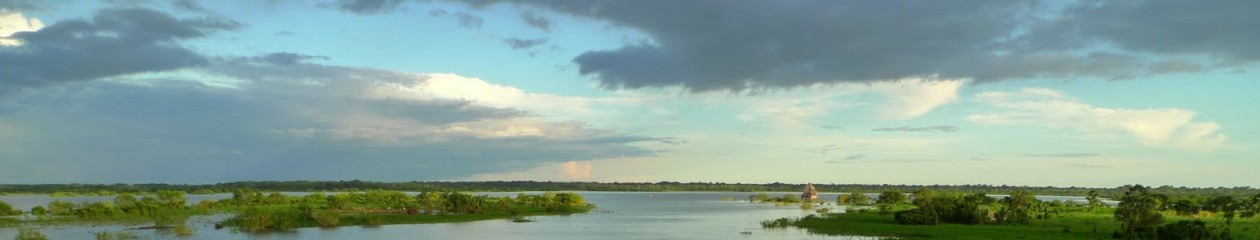
Agdam in the distance.

20140918_175741_edited

An Armenian/Karabakhi bunker from behind, facing Azerbaijan.

20140918_175906_edited

An Armenian/Karabakhi bunker from the front, facing Armenia.

20140918_180712_edited

An uncleared minefield between the lines, with the hulks of tanks and APCs from the war.

20140918_180025 (2)_edited

20140918_180550_edited

An Armenian village, totally destroyed by the fighting. It’s on a smaller scale, but gives a flavor of Agdam.

20140918_182923_edited

20140918_183047_edited

20140918_185628_edited


A blown up bridge.

20140918_183347_edited


*If I’d had to explain myself, it was all planned. As I said, the game is to act ignorant, confused, and oblivious. The conversation would have gone something like this:

Soldier: What are you doing here?
Gray: Captain, I’m sure glad to see you. I’m looking for a place called Agdam, and I’ve gotten myself half lost. I’m visiting from America, why do you ask? (always address him by one rank, but only one rank, above his actual rank)
Soldier: You cannot be here. This is a restricted area.
Gray: You don’t say? But I think I have the proper visa here in my passport, see?
Soldier: This allows you into Karabakh, not Agdam.
Gray: Ah, I see. But I have my papers here, from the Foreign Ministry, and they plainly say that I can travel to Agdam.
Soldier: Your papers do not say that you can go to Agdam.
Gray: Of course they do, look here. (points at “Askeran”)
Soldier: That says “Askeran”, not “Agdam”.
Gray: Ah, I see that now. That Consular Officer really has the worst handwriting. I had no idea, but it’s a good thing you stopped me before I got to Agdam.
Soldier: We’re in Agdam now.
Gray: That can’t be right, my GPS shows that we’re in Askeran, see?
Soldier: No, if you zoom in, you’ll see that you’re in Agdam.
Gray: I see that now. Well, good thing you found me, I could have gotten myself into trouble! You know, this place is a real mess, and looks dangerous, what with the soldiers and landmines and all. You all really shouldn’t be encouraging tourists to come here. (walks away)

(If things get particularly dicey, you go straight to “Is there any way that we can resolve the issue right now?”. If they’re dense, you follow it with “I’d by happy to pay any additional charges or fees.” Finally, if things get really bad, you can use the “ejection seat”. But it should be treated like an ejection seat, it’s expensive and dangerous, but it works when nothing else will. Produce a $100 bill–it needs to be USD, not Euros or the equivalent in local currency. Fold it twice, slip it into the front shirt pocket of the person you’re dealing with, without saying a word, and walk away.)

“You Must Go To Karabakh…”

“You must go to Karabakh…”

So said literally every person I’d spoken to about Armenia. For Armenians, it is considered the most beautiful part of the region. For backpackers, it’s a wild and remote region, largely inaccessible, often dangerous, and therefore likely to improve their feelings of self-worth based on “authenticity” and “adventurousness”. Either way, everyone suggested that I go. For some reason, the statue that is pictured in the banner of the post is considered the symbol of Karabakh.


20140918_172351_edited

 Nagorno-Karabakh was once an autonomous republic within Azerbaijan. The people there were majority Armenian, and voted to secede Azerbaijan and join Armenia. A war resulted, with Armenia fighting on behalf of Karabakh. It ended with Armenia/Karabakh occupying Nagorno-Karabakh, as well as some adjacent parts of Azerbaijan proper. Both sides behaved dreadfully, and Karabakh is now bereft of Azerbaijanis. Ethnic violence including targeting of civilians and destruction of towns and cities happened on both sides. It’s now de facto independent but also largely a client state of Armenia.

IMG_0571_edited

“Nagorno” simply means “mountainous”, so everyone refers to it as simply “Karabakh”. The Armenians consider this an Azeri term, and so properly call it “Artsakh”, but even they slip up and call it “Karabakh”. The region is entirely forbidding terrain, and is considered the most beautiful part of Armenia, or Azerbaijan, or whatever. If you look at breakaway regions, you’ll learn very quickly that people only fight over beautiful places. (Or, in a few rare instances, resource-rich areas.) No one, for example, is fighting over western Kansas anytime soon.

IMG_0550_edited

Once again, the trip was overland and off-road, so once again, I arranged the local crag-hopper, the Lada Niva. Getting in is a relatively straightforward and beautiful drive from Yerevan. There are two roads between Armenia and Karabakh, but foreigners can only enter via the southern road. In recent years, it’s been mostly paved, primarily thanks to the Armenian-American community, primarily Kirk Kerkorian.

IMG_0556_edited

Once you cross the border, you have only three hours to reach the Karabakh Ministry of Foreign Affairs (a skeleton operation, as they aren’t recognized as a country, and so don’t have “foreign affairs” per se). There you apply for and receive a visa, which grants you access, and insures that you can never again visit Azerbaijan. You also receive your “papers”, that specify exactly where you can go. If you aren’t specifically granted access, you cannot go. Think Vichy France.

20140930_023654 20140930_024003

The main town, Stepanakert, is nestled in a small saddle valley, and looks and feels much like any other town. But nearby, things are much different. It’s only a few miles to the front-lines, and fighting has increased in recent months. Also nearby is Shushi, formerly a majority-Azeri town (inside Karabakh, a majority Armenian-region, which was inside Azerbaijan, a majority-Azerbaijani country), now occupied by Armenians who fled Azerbaijan. There are similar towns in Azerbaijan, where Azerbaijani refugees moved into the homes of Armenians who’d fled.

IMG_0599_edited

IMG_0594_edited

There is an airport that was constructed with Armenian financing in 2011. It is brand-new, and state-of-the-art. But no plane has ever landed or taken off. Because no state (including, strangely, Armenia) recognizes Karabakh as an independent state, the International Civil Aviation Authority considers it Azerbaijani airspace. And so it seems that no traffic is likely for the foreseeable future. (Realistically, it’s almost certainly intended not as a civilian airport but as a military airstrip in the event of hostilities, disguised as a civilian airport. Surely they knew beforehand that no one would be able to fly in or out.)

20140918_171509_edited

There are a number of monuments around to the Karabakhi/Armenian forces, mostly tanks from the conflict, now outdated, with their turrets always aimed toward Azerbaijan. (Don’t worry, the explosive reactive armor on this T-72 was removed, and only the boxes remain.)

20140918_173804_edited

20140918_173555_edited

20140918_173536_edited

Nearby is Agdam, a strange and almost mythical place, closed to the outside world. Tomorrow, that’s where we’ll try to go.

McDonald’s Georgia: The Beef Roll

Of all the McDonald’s products in the world, the Beef Roll has to have the least appetizing name. But don’t be deceived.

20140903_184956

This thing is a monster, way more filling than a Big Mac. It’s a large flour tortilla with two all-beef patties, lettuce, tomato, onion, shredded cheese and sauce. The all-beef patties are either the 1/4 pound Quarter Pounder patties or the 1/3 pound patties that go on the Big Tasty, which is an international version of the Big & Tasty with bigger patties and a smokier version of the Big & Tasty sauce. So basically what you’re working with is a smoky double Big & Tasty served in a tortilla.

20140903_185109

If the name and pictures don’t do it for you, that’s understandable enough. But I guarantee that if you like fast food, you’ll like this. And if you don’t like fast food, you’re either a vegetarian or a charlatan.

Odessa, Ukraine

IMG_2170_edited

IMG_2159_edited

Odessa, on the Ukrainian Black Sea coast, was famous for it’s beauty in the days of the Russian Empire. With a heavy French influence, it became popular with the aristocratic elite, along with much of the Black Sea coast, especially Crimea. I’ve always wanted to visit Sevastopol, but the crisis in Ukraine prevents me, so Odessa provides a great back-up. The city is probably most famous as the home of the Potemkin steps, featured in Sergei Eisenstein’s Battleship Potemkin, about the famous Russian Imperial Navy mutiny. However beautiful they may have once been, the steps have now been ruined by the monstrosities constructed on the pier at their base.

IMG_2144_edited

IMG_2176_edited

Following the Russian annexation of Crimea, it’s now also home to what remains of the Ukrainian Navy.

IMG_2111_edited

IMG_2131_edited

Odessa has a large Russian-speaking minority, so there have been concerns over what the future here will bring. The only out-of-doors political activity that I witnessed was a pro-Ukraine parade one afternoon. Note the kid with the light machine gun.

IMG_2149_edited

IMG_2134_edited

IMG_2140_edited

Only a handful of Odessans turned out in support. This guy had the right approach.

IMG_2179_edited

Taking advantage of the week currency, I went to the ballet at Odessa’s world-famous opera house. I had a box to myself–for $4.

IMG_2205_edited

IMG_2225_edited


Kiev: The Frontier of Europe

Kiev, capital of Ukraine, looks and feels like Europe It’s increasingly cosmopolitan but has beautiful old architecture abound. As with other former Soviet cities, it has it’s growing pains–like Moscow, every restaurant offers bad sushi, every bar offers karaoke, and every lounge offers hookah, those being the “in” things to do, like Europe circa 1998.

The modernization of Europe has proceeded west to east since the fall of the Berlin Wall. In the 1990s, the places to find a European feel but at low cost and with a bit of an edge were Prague and Berlin, both long since sterilized. In the 2000s, it was Budapest or Krakow. In the 2010s, you have to go further still, to Kiev or Bucharest. Because of the political situation in Ukraine, money has been flowing out of the country at a furious pace, forcing the near collapse of the Ukrainian currency, the hryvnia (not misspelled, just unpronounceable). It’s down by around 40% this year, which makes Kiev a traveler’s paradise. The collapse is recent enough that imported goods are still widely available, and it hasn’t yet been accompanied by domestic price inflation. The result is that you can have anything you like, but it costs about half of what it should.

I won’t go into the political situation in Ukraine in any more detail here, having already covered it, except to point out that the large public square in the photos below is the Maidan, home to the Euromaidan protests that toppled the government earlier this year.

This slideshow requires JavaScript.

McDonald’s Russia: The Greek Mac

This may not have gotten much publicity in the west, but the Russian government responded to US/EU sanctions with sanctions of their own. They banned the importation of food products from the US and Europe. This puts pressures on Russia’s pro-western “café culture”, Eastern European economies, and, most importantly, western multi-national chains like McDonald’s.

IMG_9963

Then Putin went a step further and had health authorities make an example of Moscow McDonald’s locations under the guise of sanitary concerns. (McDonald’s in other countries are cleaner than hospital operating rooms, for the record). Thus for the second consecutive country, McDonald’s has become a hard to find commodity. I understand there’s a war on, but for God’s sake, this is just cruel.

I finally managed to find an open McDonald’s in Yekaterinburg. They offer a pretty straightforward US menu, with two exceptions: the Greek Mac and Brie Bites. I had to go twice. The first time I ordered a Greek Mac and Brie Bites, and got a Big Mac and fries. The second time I ordered a Greek Mac and Brie Bites, and got a Greek Mac and Brie Bites.

IMG_9967

The Greek Mac is two Big Mac patties with iceberg lettuce, tomatoes, onions, and tsatziki served in a pita pocket. It’s not that complex of a flavor. The tomatoes are a nice touch and the tsatziki is good, but it’s no special sauce. The pita is messier and more unwieldy than the normal Big Mac bun. And a hint of Greek seasoning on the beef patties would go along way. It’s no Big Mac, but it’s still better than anything you’ll find at Burger King.

IMG_9972

The Brie Bites are what we call cheesesticks in the US, but in the shape of triangles. In the US, you’ll occasionally hear complaints that we can’t get real brie because of USDA food safety concerns. Maybe we shouldn’t take our fake-brie for granted. If what they call “brie” here is even a dairy product, I’m Boris Yeltsin.

Name Your Communists

With the collapse of the Soviet Union, statues honoring Communist leaders were pulled down all over the USSR. Some of them have been gathered near Moscow’s Gorky Park, where they’re displayed in whatever condition they were found.

So, without further ado, here is everyone’s favorite game, “Name Your Communists”.  Everyone who gets all correct receives a free hologram refrigerator magnet that’s either Putin or Medvedev, depending on the angle. Submit responses by email or in comments.  Old people, Soviet historians, and nerds admittedly have an unfair advantage here.

A couple of hints: one Communist appears twice, one photo isn’t a Communist at all, and the last two are the most difficult.

1.IMG_0350_edited

2.IMG_0352_edited

3.IMG_0355_edited

4.IMG_0358

5.IMG_0361_edited

6.IMG_0365_edited

7.IMG_0368_edited

8.IMG_0371_edited

9.IMG_0373_edited

The Trans-Siberian Railroad

The Trans-Siberian railroad is the longest and most famous railroad in the world. The entire journey takes over a week without stops, if you take the traditional St. Petersburg-Vladivostok route. In some cases, on a single ticket, you can travel from Belarus or Ukraine to North Korea, covering almost half the globe. When it was completed, it was considered an engineering marvel for the ages, like the American trans-continental railroad a couple of times over.

Today, there are three routes that are collectively called the Trans-Siberian. All three follow the same route east from St. Petersburg to Irkutsk in Siberia, via Moscow, Yekaterinburg, Omsk, and Novosibirsk. The Trans-Siberian proper continues from Irkutsk east to Vladivostok. The Trans-Manchurian follows the Trans-Siberian proper east from Irkutsk before turning south and entering Manchuria and China. The Trans-Mongolian turns south just east of Irkutsk, through Mongolia and on to Beijing.

Mongolia operates in a different rail gauge (i.e. width between rails) than either China or Russia, so that has to be addressed at border crossings. On the border between Spain and France, they have the same issue, but use a device that automatically changes the width between wheels, a process taking about 20 minutes. Here, they break the train up and jack up each car (with passengers and luggage still aboard) to change the bogies (or “trucks”) by hand. This process takes between 6 and 11 hours.

Because I’m coming from China, I took the Trans-Mongolian, with multiple stops along the way–in Ulan Bator (Mongolia), Baikalsk (Russia), and Yekaterinburg (Russia) before terminating in Moscow. Because of the stops, the trip took a couple of weeks. The pictures here are my attempt to provide an unbroken image of the train trip. I’ll address the stops along the way separately. These are in chronological order, east-to-west, Beijing-Ulan Bator-Lake Baikal-Yekaterinburg-Moscow.


IMG_7799_edited IMG_7804_edited IMG_7828_edited IMG_7838_edited IMG_7847_edited IMG_7864_edited IMG_7881_edited IMG_7894_edited IMG_7897_edited IMG_7945_edited IMG_7949_edited IMG_7951_edited IMG_7964_edited IMG_8007_edited IMG_8035_edited IMG_8045_edited IMG_8100_edited IMG_8121_edited IMG_8124_edited IMG_8139_edited IMG_8155_edited IMG_8200_edited IMG_8209_edited IMG_8222_edited IMG_8225_edited IMG_8233_edited IMG_8264_edited IMG_8267_edited IMG_8273_edited IMG_9145_edited IMG_9163_edited IMG_9185_edited IMG_9197_edited IMG_9203_edited IMG_9221_edited IMG_9230_edited IMG_9756_edited IMG_9760 (2)_edited IMG_9772_edited IMG_9787_edited IMG_9790_edited IMG_9799_edited IMG_9811_edited IMG_9819_edited IMG_9844_edited IMG_9849_edited IMG_9852_edited IMG_9877_edited IMG_9926_edited

The Mongolian Steppe (cont’d)

IMG_8869_edited

Ronald Reagan famously quoted Will Rogers in saying, “There’s nothing better for the inside of a man than the outside of a horse.” It was a damn lie when Will Rogers said it, and even more so when Reagan quoted him.

Winston Churchill once said, “I have always considered that the substitution of the internal combustion engine for the horse marked a very gloomy milestone in the progress of mankind.” Spoken like a cavalryman, and like a true asshole.

You show me a post-pubescent male who enjoys horseback riding, and I’ll show you a masochist.

I hate horses, but was assured that Mongolian horses were shorter and smaller and therefore more pleasant. They are not. The saddles are narrow, and high, and metal. Whatever they were designed for, it was not for a human to sit in. The stirrups aren’t adjustable, and if you’re reading this, you’re taller than the average Mongolian man, so you’ll end up as I did, with your legs tucked close underneath like a racehorse jockey.

IMG_8809_edited

I joined my second host to go find his two camels, to ride the following day, but weren’t able to find them, which is pretty much the way things go around here. So we headed back to the ger for some fermented mare’s milk. Drinking fermented mare’s milk is sort of like smelling dogshit—once you’ve done it, you’ll never undo it as long as you live. But unlike smelling dogshit, you get used to drinking sour mare’s milk. You take turns drinking from a big bowl. Who drinks is determined by playing a game similar to rock-paper-scissors. I never quite understood the rules, but was good enough to have my share of the booze. (I may have the causation backwards there—maybe I didn’t understand the rules because I had my share of booze.) In any event, you haven’t been drunk until you’re been drunk on sour horse milk.

IMG_8711_editedIMG_8752_edited

IMG_8755_edited

IMG_8791_edited

IMG_8785_edited

My third host has things figured out. Rather than moving the yurt, he’s built himself a spring camp, summer camp, and winter camp. All of the furniture and furnishings still move, but not the houses themselves. They were the least nomadic of the group, with a son studying in Germany and a daughter studying acupuncture in China. (As an aside, I saw pictures, and it ain’t acupuncture she’s doing in China.)

IMG_8824_edited

I joined his son to herd (corral? gather? I don’t know) their sheep and goats, by motorcycle. If this isn’t obvious, if you’re doing it by horse instead of motorcycle, you’re doing it wrong. You can even use the horn to save your voice.

Afterwards, they took me to an “oasis”, which turned out to be a large puddle. Then they asked if I would help them in the field for “a minute”. After four hours of back-breaking labor (gathering “fuel” from the world’s largest dung heap, scything and threshing hay by hand), we returned back to the summer camp for my last night in the wild. We’re so far north that this time of year, the sun comes up at about 4am and sets about 9pm. They start late and work right up until sunset. They have to quit at sunset because the temperature drops precipitously. I’m guessing it falls by between 20 and 30 degrees in the first hour. It falls so fast that water condenses on everything, just like the morning dew. You won’t believe this, but it drops so fast that you can feel the relative warmth of objects around you—buildings, piles of hay, anything—on your skin as you approach them.

IMG_8847_edited

IMG_8889 (2)_edited

IMG_8885_edited

So here I am, in Mongolia, living with nomads, on a diet without fresh food, freezing by night and burning by day, without electricity and water, using an open field for a latrine, and spending hours laboring in the fields without any tools or shade. And you think to yourself, “Gray, are you on vacation, or imprisoned in a Soviet gulag?” The answer is that sometimes I don’t know either.

IMG_9053_edited

IMG_9104_edited


The Great Wall of China

IMG_7691_edited

We’d hoped to take a weekend trip outside the city—Vince hasn’t had fresh air in quite some time. We signed up for a weekend camping trip, but it was canceled. So we opted for a Saturday trek on the Great Wall, borrowed some camping gear, and separated from the group half-way in. It worked out even better because we had the Great Wall all to ourselves.

IMG_7743

IMG_7747_edited

I’d intended to skip the Great Wall, but everyone insisted that I go, and I’m glad I did. Like Machu Picchu, the natural setting is where the beauty comes from, and the structure itself amazes you that anyone would ever go the trouble. As long as the wall was garrisoned with over a million troops, everything worked well. But as soon as it wasn’t, it was overrun. In this terrain, the wall doesn’t make much difference—the hills are themselves a wall. As General Patton famously said, “Fixed fortifications are monuments to the stupidity of man.”

IMG_7759_edited

IMG_7763_edited


Beijing: Tianamen Square and the Forbidden City

Beijing is less centralized than Shanghai, with a handful of commercial districts instead of a single central business district. Well, they have something called the “Central Business District”, it just isn’t the only central business district. Most of the famous tourist sites associated with Chinese Han culture are here—the Forbidden City, the Summer Palace, and the most accessible parts of the Great Wall. The metropolitan area here is as large as Shanghai, over 25 million people, and growing fast. As a result, the air pollution here is something inconceivable in the west. EPA guidelines set a limit of 80 parts per million (ppm). I lucked out and had relatively clear days, mostly between 180 and 220 ppm. In the wintertime, when the coal burning stoves and furnaces are running full blast, it hits 800 or 900 ppm. It gets so bad that the authorities have to close the schools. It gets so bad that US government employees here get hazard pay. Don’t believe me? Here’s an unfiltered, properly exposed photo of the naked sun at about 2pm on a weekday.

IMG_7473

Beijing is also even more first-world than Shanghai. They have bbq, microbreweries, taco cantinas, Hooters, a Chinese version of SeamlessWeb, and anything else you might associate with civilization. I was enjoying the comfortable couch, chicken basil pesto sandwiches delivered to my doorstep, and HBO, but my friends insisted I see the Forbidden City, and I wanted to see Tianamen Square, so off I went.

IMG_7338_edited

IMG_7363_edited

IMG_7345_edited

IMG_7375_edited

Tianamen Square is enormous, surrounded by communist-style government buildings and featuring, at its center, a mausoleum that contains Mao Zedong’s pickled body, a la Ho Chi Minh and Lenin. The mausoleum was closed, which was okay by me—I don’t regard Chairman Mao as a particularly attractive thing to look at alive, much less dead.

IMG_7408_edited

China in general doesn’t feel like a police state, but Tianamen Square does. You pass through airport-style security to enter, uniformed and plainclothes policemen are everywhere, and thousands of CCTV cameras all around. Every lamppost has a half-dozen cameras and seemingly every other tourist is really a plainclothes cop—they give themselves away by yelling at you about what you can and cannot photograph. There’s also a permanent police garrison on site, complete with riot gear at the ready.

IMG_7380_edited

IMG_7412_edited

Adjacent to Tianamen Square is the Forbidden City, the primary palace of the Manchu emperors, or Ming emperors, or some damn thing. It was built primarily in the 13th century, or maybe the 18th, or 1953—I don’t think anyone really cares at this point. It’s full of vast open squares and intricately carved and extravagantly painted buildings, all of which look pretty much the same. And it’s huge—my pedometer told me that I walked 10 miles inside the Forbidden City looking for the Terracotta Army—which, as it turns out, is in Xi’an, 600 miles away.

IMG_7438_edited

IMG_7468_edited

IMG_7482_edited

IMG_7456_edited